Winter Storm Approaches Utah: Widespread Snow and Cold Temperatures Expected
Utah is bracing for its first major winter storm as widespread snow and cold temperatures are forecasted across the state.
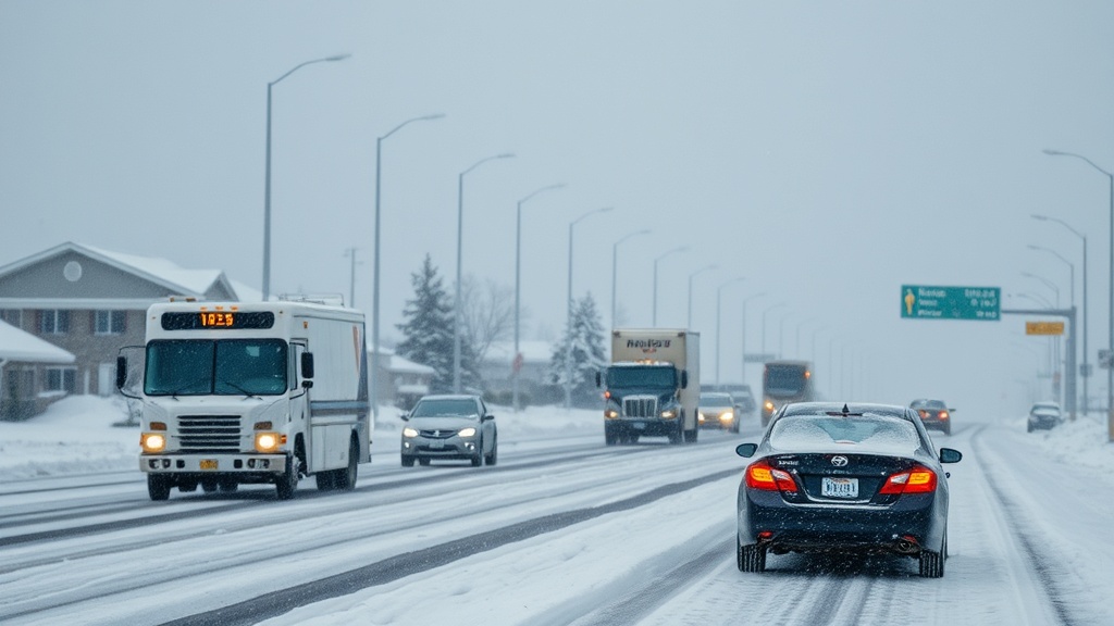
As the winter season begins to unfold, Utah residents should brace for a significant weather shift as a cold storm approaches from the northwest. The National Weather Service has issued alerts for widespread snow and colder temperatures across the state, marking the arrival of what many have been anticipating: the first substantial winter storm of the season. This anticipated change in weather patterns is expected to have a major impact on road conditions, especially for those commuting during the storm's peak.
On Wednesday, November 1, the day began with partly cloudy skies, but conditions are expected to deteriorate as the day progresses. Meteorologists predict that clouds will thicken, leading to rain in the valleys and snow accumulating in the mountains by the afternoon and evening. Drivers should expect wet roads and potentially hazardous conditions for the evening commute as rain transitions to snow.
The cold front associated with this storm will usher in the coldest air of the season, with temperatures expected to drop significantly overnight. According to forecasts, rain will begin to change to snow in the valleys by early Thursday morning, which could seriously impact morning commutes. Residents are advised to prepare for slushy or snow-covered roads, especially in low-lying areas, while mountain passes and canyons are likely to experience heavier snowfall.
The snowfall projections vary across different regions of Utah, with the northern mountains expected to see between six to twelve inches of snow by Thursday evening. The Cottonwoods and Bear River Range could receive even more, with estimates ranging from ten to twenty inches. Central and southern mountain areas are also expected to see significant snowfall, with four to eight inches predicted. Valleys may see one to four inches, while benches could receive three to six inches. Additionally, the potential for lake-effect snow could further enhance totals, particularly in parts of the Salt Lake and Tooele Valleys.
As the storm progresses, the heaviest accumulation of snow is anticipated to occur along the cold front in northern Utah in the morning hours, before shifting southward into southern Utah throughout the afternoon and evening. This progression could lead to challenging driving conditions across the state, especially for those heading out in the morning. Local transportation officials are preparing for potential road closures and delays, emphasizing the importance of caution during travel.
Beyond the immediate snowfall, weather forecasts indicate that the storm will taper off early Friday morning, leaving behind cold, dry conditions for the weekend. Valley inversions may develop, potentially leading to stagnant air and reduced air quality as temperatures remain low. Residents are encouraged to take precautions against the cold and to prepare for the possibility of power outages due to the weight of accumulated snow on trees and power lines.
In Salt Lake City, the weather forecast for Wednesday shows a transition from partly cloudy to mostly cloudy conditions, with highs reaching the mid-40s. By Wednesday night, temperatures are expected to plummet to around 30 degrees, with rain likely mixing with snow before fully transitioning to snow by Thursday morning. Thursday's forecast indicates much colder conditions, with highs only reaching the mid-30s and snow likely in the morning before tapering off in the afternoon.
Meanwhile, in St. George, the weather remains comparatively milder, with highs in the low 50s on Wednesday and a transition to mostly cloudy conditions by nightfall. On Thursday, residents can expect rain and possibly a thunderstorm, though snow may mix with rain at times, with highs only reaching the mid-40s.
As the storm approaches, residents are encouraged to stay informed by utilizing real-time weather updates and traffic alerts. The Utah Weather Authority app, available for free download, offers the latest forecasts and alerts. Additionally, local news outlets are providing continuous coverage as the storm progresses, ensuring residents have access to vital information as they prepare for winter's arrival.
In conclusion, this winter storm marks a significant change in the weather pattern for Utah as colder temperatures and substantial snowfall are set to impact the state. Residents should remain vigilant, prepare for challenging travel conditions, and stay informed through reliable weather services as they navigate the winter season ahead.